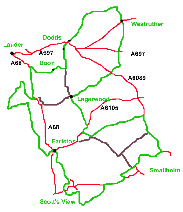
Click here for full size map
There are a few stiffish climbs, but if taken in the recomended direction these are well spaced out and not too extended. The views from the top make them worthwhile.
Continue to Corsbie, pass Corsbie Tower and join the A6089 briefly, taking a careful right turn towards Westruther.
For the next 10km or so there is a fairly continuous climb totalling around 100m to an elevation of 270m near Spottiswoode. Take care crossing the A697, and at Westruther cross the B6456 and take the back road via Spottiswoode to rejoin the A697 at Pyatshaw. (Alternate: the B6456 is usually quiet and can be taken instead, saving about 2km and some climb. This also involves a short section on the A697.)
Carefully cross back over the A697 and climb to the farm at Dodds. Follow the road to the junction near the top of Boon Hill and take the right fork to Boon. (Alternate: for a short trip, approx 24km, continue straight on and return to Legerwood down the steep Legerwood Brae.)
From the high point of 275m at Old Boon you descend to the Leader valley. Go through Boon farm, keeping your speed sensible on the steep hill in case of tractors and potholes. After crossing the Leader, turn left on to the A68 at St Leonards.
The approximately 3km on the A68 are unavoidable. However, for 2.5km there is effectively a cycle track in the marked off section at the side of the road. (Although turning right towards Lauder and then taking the back road to Blainslie involves less main road, that section is narrower and does not have a side section.)
Approaching Galadean, make a careful right turn to South Blainslie. If in doubt about traffic, stop on the left and cross the A68 when you are sure it is clear. (Alternate: take the left junction to Galadean and return to Legerwood, giving a total distance of about 31km.)
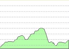
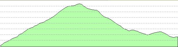
Legerwood to Galadean via Westruther and Spottiswoode
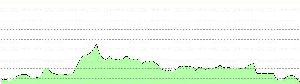
Distance 27.5km, start 182m, high 275m, low 136m, finish 146m
The Bluecairn circuit is about 7.5km with 160m of climb to a maximum of 290m, providing views of the Eildons and Cheviots. It can be taken either clockwise or anticlockwise from the Y-junction at South Blainslie. (If you wish to leave it out, go left at the junction and go straight towards Earlston).
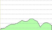
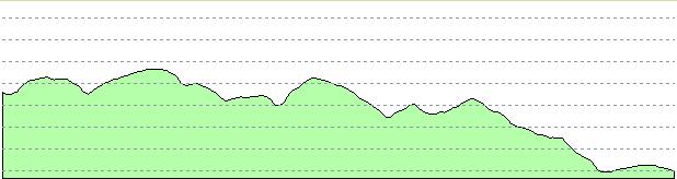
Galadean, Bluecairn to South Blainslie
Distance 7.53km, start 143m, high 288m, low 170m, finish 172m
After returning to South Blainslie, head towards Earlston and in about 5.8km, turn left down the hill into Earlston. Cross the A68 carefully, turn right after about 150m on to the B6356.
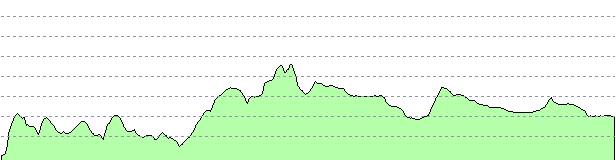
South Blainslie to Earlston
Distance 9.76km, start 172m, high 194m, low 99m, finish 100m
(Alternate: continue through the town on the A6105 to West Morriston, then turn left back to Legerwood. This road is generally OK for cycling, but can somtimes be busy and carries HGVs during the week. Excluding the Bluecairn loop this gives a total run of about 42km, or 50km including it.)
Follow the B6356 for about 3km and take the right turn signposted to Redpath (pronounced `Ripath'.) do not take the right hand turn to the village as this is a cul-de-sac but continue on until you reach the B6360 which you cross and climb to Scott's View. Stop at the viewpoint, recover your breath and appreciate the scenery.
Continue downhill to Bermersyde, then turn left towards Smailholm. After 2.5km you reach Third and turn left at the junction. There is a short but steep climb to join the B6360, turning right. Do not go to Smailholm village, but turn left at the next junction, about 2km, to New Smailholm. Stop at the top of the hill and look back to Smailholm Tower. (If you want to visit the tower, well worthwhile if you have time, energy and haven't been before, then instead of turning left, continue to the village and follows signs. This adds about 8km and some climb.)
Continue on downhill to reach the B6397.
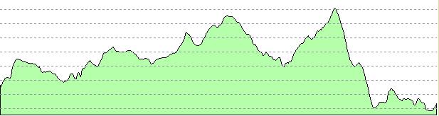
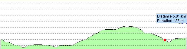
Earlston, Scott's View, New Smailholm to B6397
Distance 13.8km, start 100m, high 192m, low 100m, finish 139m
B6397 to Mellerstain turning, junction for Hume Castle is red dot
Distance 5.65km, start 139m, high 183m, low 114m, finish 146m
If you are game for the full route, turn right carefully and start the 75m (250 foot) climb to Hume Castle. It is worth dismounting at the castle and going at least part way up the hill for the view. If you have time it is worth going right to the top.
Go down to join the B6364, and turn left. On reaching the A6105 turn left. (Alternate for ATB: you can avoid approximately 2.5km on the main road by heading back the way you came about 1km and turning right to The Bield, emerging after a very rough and frequently muddy track at Bellitaw from where there is a metalled track to Middlethird. NOT advised for a road bike, I ended up pushing mine!)
Follow the main road towards Gordon, but turn left to Middlethird. Follow the back road until you reach the A6089, turn left for about 500m and then right towards Fans.
Hume Castle from A6098 back to Fans junction on A6097
Distance 16.9km, start 137m, high 209m, low, finish 134m
|
|
|